Battle at the Sajó River || The Mongol Empire XCIII

[By Chuck Almdale]

[NOTE: If maps, pictures and legends don’t display properly in your email, go to the blog. Interactive Google maps may not work in your email but will work on the blogsite. There is a link at the bottom to the entire Mongol Empire & Rus’ series.]

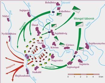
Interactive Google Satellite MyMap, modified, Sajó River environs .

The Hungarians Encircled

Exactly where the primary battle between the two armies took place is uncertain and as usual, versions differ. Almost certainly the armies met in the open, near the Hungarian camp not far from the Sajó River, somewhere south of the stone bridge. Batu Khan was well outnumbered as Subutai had taken half the army to cross the Sajó to the south. In the initial battles at the bridge over the Sajó and near the Hungarian encampment, many died on both sides. Before Subutai arrived with his half of the army, Batu’s force took such a beating that he considered withdrawing, a nearly unthinkable situation for a Mongol commander. But off to the south and out of sight of the battle, Subutai’s 30,000 troops finally crossed the Sajó, reformed, and raced to the battlefield. The Hungarians, now attacked from the rear by yet another swarm of Tatars suddenly appearing from nowhere, fell back to take refuge within their “fort” of lashed-together wagons and hastily-constructed earthworks. By now it was well past “the second hour of the day” [5:15-6:15 am].

Four miles from Mohi bridge to upstream bridge, five miles to downstream bridge.
Source: NewWorld Enclyclopedia – Battle of Mohi 

The Hungarians now found themselves pinned down within their rudimentary fortification. If they could have fallen back all the way to Pest rather than cluster within their circle of wagons, things might have gone far better for them. However, Subutai’s 30,000 troops appearing in their rear probably nipped that thought in the bud. The Hungarian’s “fort” gave them some protection, but the Mongols had them nearly surrounded, with time to bring up any heavy siege equipment or flame throwers they may have brought across the Carpathians.

Archdeacon Thomas of Split in Historia Salonitana  continues (pgs. 267-269):

The Hungarians, seeing that they were surrounded on every side by bands of the enemy, lost all sense and reason. They were unable to set their minds to drawing up their forces or to joining a full-scale pitched battle. Dazed at the enormity of their situation, they wandered to and fro like sheep in a sheepfold trying to evade the jaws of the wolf….They did not hold their shields against the storm of arrows and spears, but instead turning their backs they fell, so many everywhere, like acorns scattered when an oak tree is shaken. And when all hope of saving their lives was spent, and death, as it were, passed through the camp gazing in their faces, the king and the leading men, abandoning their standards, turned to seek refuge in flight. Then the rest of the army, terrified at the swift toll of deaths and stunned with fear of the devouring flames all around them, set their hearts on nothing else but flight. But when they sought to snatch themselves from all these dangers by fleeing, they encountered another problem close at hand and on their own side. For the way along the paths had been hazardously impeded by the maze of ropes and the closely pitched tents, and in their haste to run out of the camp, one man trampled upon another, and the numbers brought down by their own fellows falling on them seemed hardly less than those struck down by the enemy arrows.

The Hungarians discovered their water and supplies were insufficient to withstand a siege of any length. The Mongols, the men as tired as their horses, began to bombard the encampment with boulders, flaming arrows, naphtha-soaked cotton and Chinese firecrackers. Gunpowder was new to the Europeans and the explosions were intended more to terrify than to damage or maim. The Mongols were well supplied and could pillage and scour the countryside for more food and water whenever they wished. They could also stay out of range of Hungarian archers while they catapulted their missiles. The Hungarians began to realize their position was untenable; when they spotted a visible gap in the Mongol line, they decided to make a run for it.

The battle of the Sajó River: Mongol encirclement and Hungarian flight through a gap in the Mongol line. Source: Alchetron – Battle of Mohi

Archdeacon Thomas of Split in Historia Salonitana continues (pg. 269):

But when the Tatars perceived that the Hungarian army had turned to flight, they left a door open for them, so to speak, and allowed them to depart. They did not pursue them with all their force, but followed them cautiously, on two sides, not allowing them to turn aside. All over the paths lay the wretched Hungarians’ valuables, their gold and silver tableware, their crimson garments, their wealth of arms.

Unfortunately for the Hungarians, this was another favorite strategy of the Mongols, the “false escape path” which we saw used at the Battle of the River Kalka in 1223 (Part XLVI). When the Hungarians clambered over their tent-ropes, charged through the gaps in their wagon-fort and sped through the space they saw in the Mongol line, they became strung out and disorganized and found themselves surrounded on both sides by long lines of well-armed Mongol cavalry showering them and their horses with arrows.

Battle Tactic: Open the End. Source: Behance – Genghis Khan Military Tactic

Archdeacon Thomas of Split in Historia Salonitana continues (pg. 269):

But the Tatars, with their unparalleled savagery, paid little heed to all the rich plunder, intent only on human carnage. When they saw that their enemies were exhausted from running and unable to stretch out their arms to fight or their legs in flight, they began to rain spears upon them on all sides and to cut them down with swords, sparing no one, and butchering them like animals. Left and right they fell like leaves in winter; the whole way was covered with their wretched bodies; blood flowed like the stream of a river. The hapless country far and wide was red, stained with the blood of her sons. Then the pitiful multitude, those whom the Tatar sword had not yet devoured, by necessity came to a certain marsh. They were not given the chance to take a different way; pressed on by the Tatars, almost the whole of the Hungarians entered the swamp and were there dragged down into the water and the mud and drowned almost to a man. There perished the most illustrious Ugrinus; there perished Matthias of Esztergom and Bishop Gregory of Győr; there many a prelate and crowd of clerics met their fate.

The Hungarian retreat became a panicky rout, as Subutai had planned. The Mongols rode the Hungarians down and killed them with arrow, lance and sword. Losses are frequently estimated at 40,000-65,000 men. Archbishop Ugrin was killed. Prince Coloman was severely wounded but made it back to Pest, King Béla escaped as well. A great number of the ispáns, ecclesiastics and noblemen of Hungary were killed. It was a terrific defeat for what was then believed to be the strongest army in Europe. If this was Europe’s best army, many would think, obliterated nearly to a man in a matter of a few hours, so much the worse for the rest of us when the Mongols continue westward to the sea. It was the end of days, the gates of hell had opened and Satan was now taking possession of the earth.

Batu’s victory at Mohi. Source: KafkaDesk – On this day in 1241 the Mongol Horde

Repercussions of the Hungarian Defeat

What made this defeat even more crushing for Christian Europe was that it came only two days after the immense defeat of combined Polish and German forces by the Mongols at Legnica. Two days!

Duke Henry’s Silesian army was destroyed at Legnica on April 9th; King Béla’s Hungarian army obliterated on April 11th. As the news quickly spread throughout Europe, people were stunned and terrified. How many Tatars were there? Millions? How soon would they appear at our gates? Tomorrow? The Poles and others thought that supernatural powers were at work, or that Mongols weren’t exactly human. Perhaps this was Armageddon and they were a demon army pouring out from the yawning gates of hell, or even unleashed by the hand of God as punishment for the European’s innumerable sins. Genghis Khan had once said words to that effect:

I am the punishment of God…If you had not committed great sins, God would not have inflicted a punishment such as me upon you.

— Genghis Khan

Well…maybe Genghis Khan said that, or something like that. What is certain is that the Mongols were very human. They simply had excellent training, discipline, efficiency and order, four qualities European armies then lacked. They also had wonderful horses with great endurance that would find their own food in the fields. Their archers — and all Mongolian men were archers from the moment they could pick up a bow — could shoot with accuracy from the back of a galloping horse without needing to hold the reins. They enjoyed riding, hunting, battle, looting, taking slaves and concubines, and outwitting, harassing and terrorizing the settled peoples of the world. These are qualities shared to varying degrees by all peoples everywhere, since long before human history began. The Mongols, in their day, put these qualities together better than anyone else.

Size of the two armies

As said above, versions of this battle differ, especially when it comes to estimates of the sizes of the two armies. The tendency seems to be to inflate the size of the army you do not support; this makes the Mongol victory even more stupendous, or the Hungarian loss more inevitable. The contemporaneous account of German Epternacher Notiz reported Hungarian losses at 10,000 men; as their loss of men was nearly total, the army also around 10,000 men. From the Mongol side, Historian Rashid al-Din numbered the entire Mongol force invading all of Central Europe at 40,000 cavalry, only some of them at Mohi. Juvayni, also from the Mongol side, numbered the Mongol “reconnaissance force” at 10,000 and the Hungarians at 20,000.  Mongols themselves claimed the Hungarian army was twice as large as theirs. Wikipedia frequently says Hungarians numbered 60,000-80,000. HistoryNet.com says: Hungarian forces numbered 60,000-70,000, of which they lost 40,000-65,000; Mongolian forces numbered 50,000 for the main and Transylvanian flank armies, and 20,000 in Poland. Britannica says Hungarians lost 60,000 of 100,000 men, and Mongolian losses out of 80,000 men are unknown. Other sources say Mongols numbered 200,000 and Hungarians 400,000. One chronicle claims 500,000 Mongols for the entire invading force. Sam Djang in Genghis Khan: The World Conqueror says the entire invading force was around 150,000; 30,000 stayed in Russia/Kiev, 20,000 went to Poland, leaving 100,000 for the central and southern Hungarian invading forces. Some sources estimate that whatever their sizes, Hungarians outnumbered the Mongols two-to-one. Others think they were roughly equivalent. This will likely never be settled, so choose your side and pick the numbers you like; someone, somewhere will agree with you.

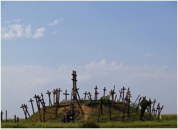
Burial Site at Mohi In Eastern Hungary (Photo: Sebastian Mrozek).
Source: Europe between East and West – King Bela


Entire Mongol Empire & Rus’ Series: Click Here
First Installment: Why didn’t the Mongols Conquer Europe in the 13th Century?
Previous Installment: Dawn on the Sajó River || Mongol Empire XCII
Next Installment: The Siege of Pest || Mongol Empire XCIV

This Installment: Battle at the Sajó River || Mongol Empire XCIII

Sources
History of the Bishops of Salona and Split (Historia Salonitana), Archdeacon Thomas of Split; General Editors: János M. Bak, Urszula Borkowska, Giles Constable, Gerhard Jaritz, Gábor Klaniczay; Central European University Press, 2006 Budapest and New York. Link to free PDF.

Mongol Invasion of 1241 and Pest in Hungary, The; János B. Szabó; Academia.com. Link to free PDF.

Britannica  – Mohi, Battle of
HistoryExtra – Medieval, Genghis Khan Warlord 
HistoryNet –Mongol Invasions, Battle of Liegnitz
HistoryNet –Mongols on the march & logistics of grass
MilitaryHistoryFandom – Mohi, Battle of
NewWorldEnclyclopedia – Mohi, Battle of
Substack – Mohi (1241), Battle of
WeaponsAndWarfare – Sajó River, Battle of
Wikipedia – Batu Khan
Wikipedia – Carmen Miserabile
Wikipedia – Central Europe, Mongol Invasion of
Wikipedia – Holy Roman Empire, Mongol Incursions into
Wikipedia – Hungary, First Mongol Invasion of
Wikipedia – Mohi [Sajó River], Battle of
Wikipedia – Mongol Invasions and Conquests
Wikipedia – Sajó
Wikipedia – Subutai
ZCMS.Hu – Muhi, Battle of

The Battle of the Indus and the Return Home | The Mongol Empire: Part XXXVII

[By Chuck Almdale]
[NOTE: If maps, pictures and legends don’t display properly, go to the blog.
The interactive Google map at the end of this posting works on the blogsite, if not in your email.]

Genghis Khan route from Taliqan [west Afghanistan] to Durzab & Gurziwan, then to Bamiyan via northern route through Balkh. Google map.

Genghis Khan Moves East

After Genghis Khan sent Shigi Qutuqtu off to deal with Jalal al-Din, he rounded up the remaining armies and set off in the general direction of Parvan. Shigi would deal with the immediate problem of al-Din, and the Khan could proceed more slowly, taking cities as they moved along.

Baba Mountain, Bamyan area. Photo: Danial, 21 Jul 2015. Source: Wikipedia – Bamyan_1

The Khan’s route passed through the present-day rural districts of Durzab [Darzab, southwest corner of Juzjan Province] and Gurziwan [both east of Taliqan], where – according to Juvayni – the resistance of a stronghold delayed the army for a month. They moved on to Bamiyan [Bamyan, long famous for its enormous Buddhist statues carved into a rocky cliff], where one of Chagatai’s sons – Genghis Khan’s favorite grandchild – was killed. As vengeance for the child’s death, Genghis ordered “every living creature, from mankind down to the brute beasts, should be killed; that no prisoner should be taken; that not even the child in its mother’s womb should be spared; and that henceforth no living creature should live therein.” The siege of Bamiyan occurred in early fall of 1221, shortly after the Battle of Parwan in September 1221.

Panorama of the northern cliff of the Valley of Bamyan, with the Western and Eastern Buddhas at each end (before destruction), surrounded by a multitude of Buddhist caves.
Source: Wikipedia – Buddhas of Bamiyan. Photo: Françoise Foliot, 1975.

An interesting footnote to this siege is the common belief that this area was repopulated by Mongol troops — posted to keep an eye on the area — and their slave women, while Genghis Khan continued east to Parvan. The settlers stayed and became the ancestors of the Hazara people. The word “Hazara” most likely derived from the Persian phrase “yek hezar” (“one thousand”), for the Mongol military unit of 1000 soldiers [the Mongolian “mingghan“]. The Hazaras are currently discriminated against by the other tribes of Afghanistan. The bestselling novel (and later movie) The Kite Runner by Afghan-American Khaled Hosseini (2003) presents an up-close portrait of this discrimination.

At 175 feet tall, the world’s tallest Buddha statue was located in Bamiyan, Afghanistan, about 90 miles west of Kabul. Afghanistan’s Taliban rulers ordered the destruction of the statue on Feb. 26, 2001. The Taliban said the statues were offensive to Islam. Other sources cite the Talibani’s anger that westerners cared more about stone statues than living suffering Afghanis. (Zaheeruddin Abdullah). Source: NPR 2011/7/27

Apparently Shigi Qutuqtu met the Khan just after this mass slaughter took place, as Juvayni reports that the Khan left Bamiyan so quickly that food could not be cooked. The time of reckoning for Shigi had arrived and he gave the Khan his report. Other battle leaders had – and would be – executed for such failure, and it would not be unexpected that the Khan would be furious at the failure and the loss of life. But this was Shigi. Temüjin forgave him, saying that now that he had experienced great loss, he would more than make up for it with great victories. The Khan decided he’d better deal with this increasingly annoying Jalal al-Din himself.

The united army traveled non-stop day and night until they reach Parvan. Here the Khan inspected the battlefield and critiqued the positions and actions taken by both Shigi Qutuqtu and Jalal al-Din. [Jalal missed this important tactical lesson.] They rode south to Ghazni and learned that Jalal al-Din had been there only two weeks earlier but fled eastward for the Indus River. Genghis Khan, his sons and their army immediately set off in pursuit.

The Battle of the Indus River

Caracole Tactic: archer fires arrow while approaching and leaving the battle front, immediately replaced by next archer. Source: Behance – Genghis Khan
Painting from the epic Chinggiskhannama, illustrates Jalal al-Din Khwarazmshah crossing the rapid Indus river, escaping Chinggis Khan and his army. The river, alive with jumping fish, separates Chingis Khan from Jalal al-Din, who carries a parasol, large pole, and sword. A walled city in the distances. Gouache on paper, 1596-1600CE.
Source: Wikipedia – Jalal al-Din

Despite the two-week lead, Genghis Khan caught up to Jalal al-Din on the banks of the Indus River, probably at Dinkot [crossing], near the modern Kalabagh, while the boats were still loading. With back to the river and despite the enormous Mongol army approaching, al-Din gathered his 30,000 soldiers into battle formations. The Mongols attacked and utterly destroyed Amin Malik’s right wing. Malik was killed while fleeing northward towards Peshawar. The left wing was then attacked and likewise destroyed. Only Jalal al-Din’s center force of 700 men remained. The Mongols formed into a semicircle around al-Din’s men and attacked in wave after wave. (This may have been the caracole tactic often used by the Mongols, where constantly moving horse archers ride by firing arrows all the while at their relatively stationary foes.)

Mongols kept arriving and attacking and al-Din had less and less maneuvering room. By midday it was clearly hopeless. Jalal al-Din mounted a fresh horse, made a final charge at the Mongols now closing in to force them back, then turned in this additional space, threw off his cuirass [armored breastplate and backplate] and drove his charging horse over the bank and into the water, thirty feet below. Genghis Khan sat on his horse at the water’s edge a short distance away, watching. He ordered his troops not to follow al-Din over the bank and into the river, then ordered the archers not to shoot al-Din as he preferred that al-Din be captured alive. Then he just sat and watched while al-Din on his horse kept churning through the water until he reached the opposite shore (probably ¼ to ½ mile). As al-Din climbed ashore safe and sound, still grasping his sword, lance and shield, the Khan pointed him out to his sons with expressions of amazement and admiration, and commented, “Fortunate should be the father of such a son.” Jalal al-Din’s men were somewhat less fortunate than their leader. The vast majority of those who followed their leader into the river were killed by Mongol archers. Juvayni cites eyewitness reports that within the range of the bowmen, the river ran red with blood.

Genghis Khan spares Jalal al-Din’s life at the Indus River. Source: Jackmeister-Chinggis Khan

The End of the Campaign

The battle of the Indus was Genghis Khan’s final battle within the Khwarazmian Empire. According to Jalal al-Din’s secretary and biographer, Shihab al-Din Muhammad al-Nasawi (died 1250), the battle took place on 25 November 1221. Juvayni, who gives a much more detailed account of events leading up to the battle, says sometime between 21 August and 19 September 1221. [September 1221 is the most common date for the Battle of Parvan, which undoubtedly preceded the Battle of the Indus by at least several weeks. The November 1221 date seems more reasonable.] After this victory Genghis Khan followed the Indus upstream, then turned west into the valley of the upper Kurram, apparently seeking a suitable way to cross the river with a large army. When he learned that Jalal al-Din had come back across the river to bury his dead, the Khan sent Chagatai back to the river to resume the pursuit. The Khan continued with the main army to find winter quarters in what is now the Swat Valley, north of Islamabad, Pakistan.

Over the course of winter 1221-1222, the Khan decided to return to Mongolia by a completely different route – eastward across northern India and through Bengal and Assam, then either crossing the formidable Himalayan Mountains to presumably arrive somewhere near Chongqing, or continuing eastward through what is now Yunnan Province of China, then north to Chongqing. From Chingqing they would continue north through the Western Xia Kingdom – now supposedly a vassal state of the Mongol Empire – and from there up to his Mongolian plateau homeland. An ambitious plan!

They actually went “two or three stages” into Punjab before being forced to turn back, possibly in late winter-early spring of 1222, after breaking the Swat Valley camp. The interactive map below presents three conjectured routes from the Indus River [Pakistan] to Mongolia. The northern route is roughly the route actually taken.

Google map, interactive on the blog, not in email. Includes conjectured southern routes through India and China to return to Mongolia, plus a rough estimation of the actual route home passing through Transoxiana.

I suspect the lowland heat, insects and the unfrozen rivers were the primary problems. The Khan chose to retrace their steps inland and uphill into Afghanistan and then spent the summer in the mountains of the Hindu Kush, apparently somewhere near Parvan, north of Kabul. Here there were pastures for the horses, plentiful water, and it was a major crossroads for travelers.

Chángchūnzi. Source: SecondWiki – Qiu Chuji

While at Parvan the Khan received a visit from the Taoist monk Master Changchung [Ch‘ang-ch‘un, Qiu Chuji], one of the “Seven True Daoists of the North,” in response to a letter Genghis had written him over 3 ½ years earlier, inviting him to come and talk about the “medicine of immortality.” Changchung had come all the way from Shandong, southeast of Zhongdu [Beijing]. They talked at their leisure, until the Khan had to temporarily leave to deal with some “native mountain bandits,” possibly referring to the rebellion at Herat or at Balkh, and they met again farther north in the Baghlai [Baghlan] area to continue their conversation. The Khan broke camp on 3 October 1222 and three days later crossed the Amu Darya, probably at Mela Ford, on a bridge of boats.

Genghis Khan route (conjectured) from Amu Darya to Samarqand, Syr Darya, and Qulan-Bashi [Kulan].

By now Chagatai had given up on his fruitless search for Jalal al-Din, and was replaced by general Dorbei who continued the search. Dorbei made it as far southeast as Multan and Lahore before the heat of summer drove him back north to meet the Khan in the meadows east of Samarqand. The monk Changchung was also traveling northward on his return to China. Changchung left Samarqand on 29 December 1222 and caught up with Genghis Khan and his army a month later on the eastern banks of the Syr Darya.

According to Genghis Khan: The World Conqueror (Sam Djang), a kurultai was held in Spring 1223 at Fenaket, a city on the banks of the Syr Darya. This was before Jube and Subutai returned from their travels through the Caucasus, the lands of the Kyivan Rus’, and the Kipchak steppes. Among other event and decisions, Genghis made the following appointments: Yalavachi as viceroy of the newly conquered Khwarazmian territory; Yelu Ahai as darughachi of Samarqand; Yelu Chutze as organizer of the system of administration.

Note: I could not locate Fenaket city or area on any map nor in any useful online references. One source said it was a river, another said Fenaket was the Syr Darya river. Other sources said this kurultai may have been at Qulan-Bashi (see below). As other sources have Genghis and the monk Changchung at Qulan-Bashi during Spring-Summer 1223, perhaps the kurultai was there. In either locale, it seems that it was held before Jebe and Subutai returned from the western steppes.

The expanding Mongol Empire 1206-1294 CE. This is a GIF file, motion repeating endlessly, If it doesn’t work in your email, check the blog. Source: Wikipedia – Mongol Empire

Following the kurultai in spring 1223, Genghis Khan, the monk Changchung, and the khan’s armies spent the summer 1223 in the region of Qulan-Bashi, the pass between the Ari’s and Talas basins on the way from Chimkent to Jambul.

Note on Qulan-Bashi: In southern Kazakhstan, Chimkent [Shymkent, name of both city and regional center] is on the Arys River, and Jambul [Jambyl] is a large province northeast of Chimkent, with the Chu River running through it. Between these two areas lies the Alexander Range [now Kyrgyz Ala-Too, Kyrgyz Alatau, Kyrgyz Range]. The Talas River flows west-northwest from east of Talas in Kyrgyzstan, past Taraz and into the Talas district of Kazakhstan. In the low pass between Chimkent and the Talas river basin lies a small community of Kulan. Kulan is also the local name of the endemic wild asses. The only “Bashi” I could find is well north of this area on the Irtysh River.

Black Irtysh River, east of Lake Balkhash, one of Genghis Khan’s favorite summer gathering and resting locales in north central Asia. The Irtysh is the largest river in central Asia, the chief tributary of the Ob River which empties into the Kara Sea (Arctic Ocean) east of Novaya Zemlya island. The Irtysh drains the west and north slopes of the Altai Mountains of central Asia, and with the Ob, the east slope of the Ural Mountains of Siberia.

The monk Changchung left Genghis at Qulan-Bashi and continued on his own eastward path back to Shandong on the Pacific coast of China. [Changchung’s travelogue 1220-1223]. When the Khan and his armies left Qulan-Bashi they formed caravans of war booty and slaves many miles long and headed northeast to the Black Irtysh River northeast of the Aral Sea, which they reached by the summer of 1224. By the spring of 1225 he finally arrived back home on the Mongolian plateau. He then took a long rest. He was now 63 years old.

Black Irtysh River around 2012. Now heavily polluted with toxic substances from industry and mining activities. Source: Research Gate – Black Irtysh
Google Map non-interactive screenshot. All routes and cities following the fall of Samarqand March 1220 through return home Spring 1225. All routes and some locations are at least partially conjectural. Light green: Genghis Khan, Purple: Shah; Black: Jebe & Subutai; Tan: Jebe; Green: Subutai; Violet: Tolui in Khorasan; Blue: Jalal al-Din; Orange: other; Pale violet: Shah’s proposed trip to Ghanzi; Pink: Shah’s messengers to/from Mela ford. Baffling at this magnification, isn’t it? See interactive map below.
Punjab “land of the five rivers”, now divided between Pakistan and India.
Source: Wikipedia – Punjab

Jalal al-Din

What happened to Jalal al-Din? The Khan’s generals never found him. He again crossed the Indus River eastward to safety. Other survivors from the massacre at the Indus crossed the river and joined him and they spent the next three years in India. When he heard that a Mongol army [this time under general Dorbei] was again in pursuit and somewhere in Punjab around Multan and Lahore, al-Din and his army fled farther east, almost to Delhi. After three years, he again went west – he was still the Khwarazmshah, after all, and needed to check up on his mighty empire! – and was a thorn in the side of the Mongols for many years thereafter. I hope to catch up on his journeys at a later time.

With the next episode we again turn our space-time clock backwards to the Winter of 1220-21 and the southern border of the Kingdom of Georgia, where we will find Jebe and Subutai, spending the winter in the Mughan Steppes after their nine-month pursuit of the Khwarazmshah Muhammad II, now deceased.


Interactive (on the blog) Google Map. Click on any route or icon and information about it will appear. Zoom in/out: scroll or +/-; Details: left click on lines/icons; Move map: left click+hold & move mouse; Additional routes: upper left toggle arrow. Displayed are all routes and cities following the fall of Samarqand March 1220 through Genghis Khan’s return home Spring 1225. All routes and some locations are at least partially conjectural. Light green: Genghis Khan, Purple: Shah; Black: Jebe & Subutai; Tan: Jebe; Green: Subutai; Violet: Tolui in Khorasan; Blue: Jalal al-Din; Orange: other; Pale violet: Shah’s proposed trip to Ghanzi; Pink: Shah’s messengers to/from Mela ford.


Entire Mongol Empire Series: Click Here
First Installment: Why didn’t the Mongols Conquer Europe in the 13th Century?
Previous Installment: Shigi Qutuqtu and the Battle of Parvan | The Mongol Empire: Part XXXVI
Next Installment: The Kingdom of Georgia | The Mongol Empire: Part XXXVIII
This Installment: The Battle of the Indus and the Return Home | The Mongol Empire: Part XXXVII

Main Sources
Cambridge History of Iran, The; Volume V, Chapter 4, “Dynastic and Political History of the Il-Khans”. Boyle, John Andrew; (1938); pages 318-322.
Genghis Khan: The World Conqueror. Djang, Sam; New Horizon Books, 2011. Pages 809-810.

Other Sources
Karakalpak – Mongols
MilitaryHistoryFandom – Siege of Bamiyan
WeaponNews – Empire of Genghis Khan and the Khwarazm
Wikipedia – Battle of the Indus
Wikipedia – Jalal al-Din
Wikipedia – Khwarazmian Empire
Wikipedia – Mongol Conquest of the Khwarazmian Empire
Wikipedia – Mongol Conquest of Central Asia
Wikipedia – Invasions of Afghanistan
Wikipedia – Invasions of India
Wikipedia – Mongol Invasion of Persia

Shigi Qutuqtu and the Battle of Parvan | The Mongol Empire: Part XXXVI

[By Chuck Almdale]
[NOTE: If maps, pictures and legends don’t display properly, go to the blog.
The interactive Google map at the end of this posting works on the blogsite, if not in your email.]

Afghanistan modern regions and provinces. Source: Wikipedia – Afghanistan

General Shigi Qutuqtu

Tolui finished his three-month stint of ‘securing’ the cities of western Khorasan, and in early summer of 1221 returned to the mountains of Juzjan [now a northwestern Afghani province] where his father had laid siege to the city of Taliqan. As previously mentioned, the sources are vague and contradictory about what Genghis Khan did immediately afterwards. Second and third sons Chagatai and Ögedei had wrapped up their seven (or ten) month siege of Gurganj and town-taking along the Amu Darya and were now with him. Eldest son Jochi was absent – probably at his preferred Volga River camp in the steppes north of the Caspian and Aral Seas. Most likely, all spent their time in the mountains near Taliqan, relaxing and letting their horses fatten up. It was presumably here that the Khan received the message from generals Tekechtik and Molghor that Jalal al-Din – now the Khwarazmshah – was at Parvan. From Taliqan to Parvan was only 300 miles by crow, 450 miles by road via Balkh. Genghis selected one of his favorite commanders – the Tatar Shigi Qutuqtu – and sent him to capture or kill the new Khwarazmshah.

Shigi Qutuqtu [Shikhikhutug, Sigi Qutuku] and Genghis Khan were very close, which is a bit unusual as Shigi was the son of a Tatar nobleman, a tribe long detested by and at war with the Khan’s Borjigin tribe of Mongols. As a young child in the  early 1190s, Shigi became separated from his family during a skirmish between the Mongols and the Tatars, and was later discovered by Temüjin Khan’s men. They brought him to the khan’s mother, Hoelun, who straightaway adopted him as a son. Although he was brother-by-adoption to Shigi, the difference in their ages made Temüjin feel more like a father. Shigi became well-versed in legal matters and made major contributions to the legal code of yassa – Temüjin’s brainchild – during the early years of the empire. Genghis appointed him as a judge in 1206, and he helped create a record of legislation and criminal affairs. He was close friends with Yelü Chucai, the prime minister of the Mongol Empire. Of all of his “sons,” Temüjin may well have been most fond of Shigi, his brother and son; an example of the depth of this relationship we shall see in a moment.

Village in Parwan province, 26 Mar 2013. Source: Defense – Parwan

The Battle of Parvan

The Mongol army typically traveled quickly, far faster than their foes ever expected, and – army in tow – Shigi Qutuqtu arrived at Parvan only a week after Jalal al-Din himself returned from the battle at the castle in Walian Kotal. Sources differ on the size of Qutuqtu’s force: 5,000–30,000–50,000; a tenfold difference of opinion, but errors and exaggerations of the size of any army, Mongol or otherwise, in this entire story, are legion. Jalal al-Din immediately brought his army out to meet him and drew up his forces in battle order, assigning the right wing to Amin Malik, the left wing to Ighraq, with himself commanding the center. He then instructed the entire army to dismount and fight on foot while holding onto the reins of their horses, a tactic which seems quite odd and rife with potential problems. The Mongols concentrated their attack on Amin Malik’s right wing and drove them back until reinforcements arrived from the center and the right, and the Mongols were themselves turned back.

Golghondi, Parwan province. Source: Google – Parwan

Back and forth the battle raged until evening when both sides returned to their encampments. As we saw when Khwarazmshah Muhammad II first encountered the Mongols in Kipchak country north of the Aral Sea back in 1219, Mongols after dark are not to be trusted. They start sneaking around, and this was no exception. They set up dummy warriors on their spare horses [all Mongol cavalrymen had 2-4 extra horses], and the next morning Shah al-Din’s army awoke to find a huge line of apparent reinforcements at the rear of the enemy lines, awaiting – no doubt – the order to swoop down and slay al-Din’s army to a man. Al-Din’s soldiers thought of flight, but the shah rallied and encouraged them, and they again rode into battle against the unbeatable Mongols.

Salang pass, Hindu Kush mountains, Parwan province. Source: Wikipedia – Parwan Province

As before, they fought on foot, reins in hand, and this time the Mongols attacked Ighraq’s left wing. Ighraq’s men stood firm. The Mongols began to flag and turned about to return to their base. Suddenly, at one command, the Shah’s entire army leapt onto their mounts and charged the Mongols. The Mongols fled – this was possibly an attempt at a feigned retreat – and when they turned to counterattack or encircle, al-Din’s army swept over them like a tidal wave. Utterly routed, Shigi Qutuqtu escaped with the remnants of his army, and fled west to bring the bad news back to Genghis Khan, his brother-father-absolute ruler. The sources cite than half of Shigi Qutuqtu’s army was lost in the battle of Parvan. Depending on the actual size of the army – was it 5,000, 30,000 or 50,000 men? – that amounted to 2,500 to 25,000 lost. These were significant losses for the Mongols, with even more significant differences of opinion on the size of the loss. Out of many hundreds of battles – some sources say 800, some say 1000 – large and small throughout the Khwarazmian Empire, this was the Mongol’s only defeat of any significance.

Parwan province. Source: Afghan Women’s Writing Project

Note: There’s something suspect about this story of the battle. The idea that soldiers could effectively do much of anything, let alone fight off a charging army while using one hand to hold the reins of their horse, verges on the absurd. If nothing else, the horse would panic and jump around when this ferocious Mongol army comes charging down on him while he’s stuck there with some human hanging onto his leash. The final idea sounds good — suddenly leap onto your horse, catch and demolish the unwary enemy from behind — but everything up to that point sounds implausible. And what was Shigi Qutuktu thinking? Had he forgotten everything about proper battle tactics? His troops should have stood off a a distance or run a caracole maneuver and filled al-Din’s stationary troops and horses with arrows, not charge up and engage in hand-to-hand combat. They could have obliterated al-Din’s troops and not lost a man. I wonder if this battle ever happened at all, and wasn’t concocted to make Jalal al-Din look good. All of central Asia needed a hero. But…we continue.

Genghis Khan (green) and Jalal al-Din (blue) routes 1220-21 until the Battle of Parvan. Google map screenshot. See interactive map below for greater detail.

Among other traits, Genghis Khan admired loyalty, efficiency, honesty, intelligence. Bravery was a fine trait too if you weren’t stupid about it. Wasted effort, wasted courage and wasted lives were abhorrent to him. The best of all possible worlds was large piles of loot won without effort save stuffing it into sacks. Were the Mongol nation a corporation, Genghis Khan as CEO/chairman and the troops employee-shareholders, the corporate mission was “maximize shareholder return.” The return was loot, portable loot, things you could haul back to Mongolia on your horses or shouldered by your slaves. Equally important was staying alive to enjoy your loot. Warfare and looting are risky endeavors; every Mongol knew and accepted that. They were warriors with a skill-set refined for hunting and battling. Land pirates, looking for loot. They were not suicidal glory-seekers.

In the Khan’s army infractions or bad judgement could lose you your head, and Shigi Qutuqtu had something to worry about as he led his remaining army back to the west to inform Genghis Khan of the situation. Infractions as innocuous as failing to pick up gear dropped by the trooper ahead of you could cost you your head. Falsifying a report or trying to hide one’s own errors could cost you your head. Shigi had helped formulate the Mongolian law of yassa and could not plead ignorance. Shigi had “lost” or squandered thousands of lives, but his heart knew that when he came before the Khan he must tell him all, withholding nothing. If he was beheaded, it would be an honorable death for errors already committed, not for lies yet untold.

Jalal al-Din Mangburni statue in Urgench, Uzbekistan, 2020. Could anyone possibly look more noble?
Source: Wikipedia – Jalal al-Din

Jalal al-Din was ecstatic. He had beaten the undefeatable Mongols in fact-to-face battle. For the rest of his life his fame and his ability to rouse supporters rested almost entirely on this victory over the merciless Mongols. Even eight centuries later, he is remembered, admired and lauded for this victory throughout central Asia with statues and memorials built in his honor.

But on the battlefield Jalal al-Din’s savoring of delicious victory could hardly have been more brief. Within minutes Amin Malik and Ighraq quarreled over battlefield booty and Amin whacked Ighraq over the head with a whip. Jalal al-Din ignored the incident, hoping everyone else would likewise let it pass. Ighraq controlled his temper all the way until that evening, when he rounded up his soldiers and left. A’zam Malik, who had taken his side in the dispute, took his forces and left with Ighraq. Disheartened and now lacking an army, Jalal al-Din returned to Ghazni, where he made plans to flee eastward beyond the Indus River and out of the Khwarazmian Empire altogether.

Interactive Google Map. Click on any route or icon and information about it will appear. Zoom in/out: scroll or +/-; Details: left click on lines/icons; Move map: left click+hold & move mouse; Additional routes: upper left toggle arrow. Displayed are all routes and cities following the fall of Samarqand March 1220 through Jalal al-Din’s victory at Battle of Parvan, and return to Ghazni, September 1221. All routes and some locations are at least partially conjectural. Light green: Genghis Khan, Purple: Shah; Black: Jebe & Subutai; Tan: Jebe; Green: Subutai; Violet: Tolui in Khorasan; Blue: Jalal al-Din; Orange: other; Pale violet: Shah’s proposed trip to Ghanzi; Pink: Shah’s messengers to/from Mela ford.


Entire Mongol Empire Series: Click Here
First Installment: Why didn’t the Mongols Conquer Europe in the 13th Century?
Previous Installment: The End of Herat and the Return of Jalal al-Din | The Mongol Empire: Part XXXV
Next Installment: The Battle of the Indus and the Return Home | The Mongol Empire: Part XXXVII
This Installment: Shigi Qutuqtu and the Battle of Parvan | The Mongol Empire: Part XXXVI

Main Sources
Cambridge History of Iran, The; Volume V, Chapter 4, “Dynastic and Political History of the Il-Khans”. Boyle, John Andrew; (1938); pages 318-319.
Genghis Khan: The World Conqueror. Djang, Sam; New Horizon Books, 2011. Pages 759-760.

Other Sources
WeaponNews – Empire of Genghis Khan and the Khwarazm
Wikipedia – Battle of Parwan
Wikipedia – Jalal al-Din
Wikipedia – Khwarazmian Empire
Wikipedia – Mongol Conquest of the Khwarazmian Empire
Wikipedia – Mongol Conquest of Central Asia
Wikipedia – Mongol Invasion of Persia
Wikipedia – Shigi Qutuqu
Wikipedia – Tolui
Wikiwand – Shigi Qutuqu

The End of Herat and the Return of Jalal al-Din | The Mongol Empire: Part XXXV

[By Chuck Almdale]
[NOTE: If maps, pictures and legends don’t display properly, go to the blog.
The Google map at this posting’s end is interactive on the blogsite, but probably not in your email.]

On to Herat

“The last of all to suffer”, says Persian historian Juvayni, “was Herat, and when Tolui had joined her to her sisters, he returned to wait upon his father.”

From top: Great Mosque of Herat, Shrine of Khwaja Abd Allah, Mirwais Sadiq Khan Tomb, View of Gawhar Shad Mausoleum. Source: Wikipedia – Herat

Herat was the last of the major silk road cities taken by Tolui, and historians vary widely on this event. Juvayni left no detailed account of the capture of the town. Russian historian Vasily Vladimirovich (Wilhelm) Bartold (1869-1930), on the authority of Abraham d’Ohsson (1779-1851), whose authority in turn was a fifteenth-century local history of Herat, says that none of the inhabitants were killed, with the exception of the sultan’s troops and that Herat, in consequence, “suffered least of all.” On the other hand, Minhaj al-Siraj Juzjani (1193-1266?), a contemporary of the event who had himself taken part in the defense of a mountain fortress at no great distance from Herat, speaks of its capture after siege of eight months’ duration and the subsequent massacre of the entire population. In fact there were two sieges of Herat; both are recorded in detail in a work re-discovered in the 20th century and published in 1944. Here is John Andrew Boyle’s description from The Cambridge History of Iran (Pgs 315-316).

Greater Khorasan. Source: Wikishia – Greater Khorasan

This is the Ta’rikh-Nama-yi-Harat or “History of Herat” of Saif b. Muhammad b. Ya’qub known as Saifi. A native of Herat, Saifi was born in that city in 1282 and wrote his history at some time between 1318 and 1322. It contains a great deal of information, not recorded elsewhere, about conditions not only in Herat itself but in the whole of Khorasan in the period during and immediately following the Mongol invasion.

According to Saifi’s account Tolui, upon his arrival before Herat, encamped in the meadows near the town and sent an envoy to invite the people to surrender. The envoy was at once put to death on the orders of the malik or governor representing Sultan Jalal al-Din. Tolui, in anger, ordered a general assault, which continued for eight days, at the end of which the malik was killed in the fighting. Tolui now intervened in person, riding up to the edge of the moat and making a proclamation, in which he promised to spare the lives of the inhabitants if they surrendered immediately. To this the townspeople agreed and the Mongols kept their word except with regard to the troops of Sultan Jalal al-Din numbering 12,000 men. Tolui set a malik over the town, a Muslim called Abu Bakr of Maruchaq, and also a Mongol shahna, a man called Mengetei, a member of Tolui’s immediate entourage. Eight days later Tolui left the region to join his father.

But this was by no means the end of the story. For a time all went well, the people living peaceably under the protection of the Muslim malik and the Mongol shahna. And then, all of a sudden, they rose in rebellion and killed both of these officials. Saifi gives two versions of this rising. It was either a spontaneous movement on the part of the Heratis or else it was engineered by the people of the mountain stronghold of Kalyun to the north-east of Herat, who were still holding out against the Mongols, and hoped in this way to enlist the Heratis as their allies. According to this latter version, the assassinations were carried out by men from Kalyun who entered the town disguised as merchants with weapons concealed about their persons. Whatever the truth of the matter, the damage was now done. When the news reached Chingiz-Khan he was filled with anger and dispatched the general Eljigidei at the head of 80,000 men to mete out retribution. Saifi records his instructions: “The dead have come to life again. This time you must cut the people’s heads off: you must execute the whole population of Herat.”

Eljigidei set out in November 1221. In due course he arrived on the Hari Rud [river flowing northward into Turkmenistan], and busied himself for the next month with warlike preparations: from the surrounding regions he gathered reinforcements to the strength of 50,000 men. With this great army Eljigidei now laid siege to Herat. This time the resistance was long and heroic. It was not until June of the following year [1222] that the Mongols finally captured the town. Eljigidei carried out his instructions to the letter: the entire population was put to death, “and no head was left on a body, nor body with a head ”. Saifi assesses the number of those thus massacred at a figure of 1,600,000. (The contemporary Juzjani records that in a single quarter [1/4th of the town] there were counted 600,000 dead and on this basis estimates the total number in the whole town at 2,400,000!) For seven days the Mongols were busy with this slaughter and with demolishing the houses, filling in the moats and destroying the fortifications. On the eighth day they set off in the direction of Kalyun. When they had reached Auba (Obeh) on the Hari Rud [river], Eljigidei sent back 2,000 horsemen with instructions to kill any persons they might find who had escaped the massacre by going into hiding. They stayed two days in the town, where they discovered nearly their own number of such wretches; they put them all to death and then returned to the main body.

Tolui’s conquest of Khorasan Spring 1221, some locations approximate, actual route & sequence conjectural. Tolui accompanies Genghis Khan from Balkh to Taliqan, then Tolui circles through Khorasan back to Taliqan. Google map. Also see interactive Google map below.
Seljuq era art: Ewer from Herat, dated 1180-1210CE. Brass worked in repousse and inlaid with silver and bitumen. NY Metropolitan Museum. Source: Wikipedia – Herat

With the exception of the revolt at Herat, Tolui took only three months to conquer Khorasan. He then returned to his father, Genghis Khan, about the time that the siege of Taliqan was ending. By this time it was probably the early summer of 1221.

The famous Friday Mosque of Herat or Masjid Jami, one of the oldest mosques in Afghanistan.
Source: Wikipedia – Herat

The Return of Jalal al-Din

In the episode “Gurganj Awaits” we learned that Jalal al-Din was with his father, Khwarazmshah Muhammad II when he died on Ashooredeh Island in December 1220 or January 1221 CE. The shah, now on his deathbed, named Jalal as his sole heir to the empire. This rescinded his earlier decision favoring son Uzlagh Shah, which had been insisted upon by the Shah’s mother Terken Khadun. Not that there was much to succeed to, as the Mongols were well on their way towards conquering the entire Khwarazmian Empire. Uzlagh was present at the time Jalal was named, and there is no record that he objected at that time to his father’s decision. Nor did he object later in Gurganj when many of the city leaders rejected Jalal and expressed support for him.

When Jalal al-Din got wind of a plot to assassinate him, he fled south towards Khorasan with 300 loyal soldiers, leaving Gurganj to its fate. His brothers Uzlagh Shah and Aq Shah followed him a few days later. Timur Malik was with Jalal, or joined him later with additional loyal soldiers. They crossed the Karakum desert and reached Nesa [Ashgabat] on the northern frontier of Khorasan, Here they attacked the Mongol garrison and killed most of them, including two brothers of Toghachar, a son-in-law of Genghis Khan. Then they made their way to Nishapur. Jalal’s two brothers were a few days behind him, but like a rudely awakened rattlesnake who bites the second hiker on the trail, the Mongols killed them and paraded their heads on the ends of spears to terrify the local Khwarazmians.

Jalal al-Din stayed only a few days in Nishapur — until 10 February 1221 — before departing for Ghazni, south of Kabul, 570 miles as the crow flies from Nishapur. A Mongol force appeared just as he was leaving and gave pursuit, but he lost them by riding hard south to Zuzan in a single day, 140 miles as the crow flies. The Zuzanis would not give him refuge, so he stayed at a nearby town, and left at midnight a few hours before the Mongol pursuit force again arrived. They followed, but Jalal lost them again and they soon gave up the chase. He arrived next at Herat, 130 miles east of Zuzan. He then continued on to Ghazni, 350 miles east of Herat, but easily 500 miles by road.

Jalal al-Din leaves Ashooredeh Island in the Caspian Sea, rides north to Gurganj, then to Nisa, Nishapur, Zuzan, Herat, Ghazni and Parvan north of Kabul, Afghanistan. Google non-interactive map.

Ghazni was a welcome sight to Jalal al-Din after his hard ride and the people welcomed him. It was currently ruled by another Malik – either Jalal’s cousin Amin Malik, a Qangli Turk, who had been malik [owner, leader, headman] of Herat, or by Ghuri A’zam Malik, the son of ‘Imad al-Din of Balkh, likely the latter. Amin Malik had his Qangli troops, A’zam Malik his Ghuri troops and Saif al-Din Ighraq had a great host of Khalaj [from Persian Iraq] and Turkmen tribesmen. Jalal al-Din suddenly found himself with an army of 60,000 ill-assorted but well-equipped soldiers.

Fortress and citadel of Ghazni (Afghanistan) and the two Minars, a painting by James Atkinson, c.1839; the minars were constructed by Bahram Shah in the early 1100’s. Source: Wikipedia – Ghazni

The winter sped by in Ghazni and with the spring thaw Jalal al-Din led his army north to Parvan [now Parwan province, 20 miles north of Kabul], where many crossroads met at the merging of the Ghorband and Panjshir rivers. Learning of Mongols in the area, they went northwest up the Ghorband River to where a Mongol army, led by generals Tekechtik and Molghor, were besieging a castle in the Walian Kotal [‘Kotal’ = mountain pass]. After al-Din’s army had killed a thousand Mongols, one or other of the armies withdrew across the river and destroyed the bridge behind them. The two armies shot arrows at each other until nightfall; the Mongols then left under darkness and Jalal al-Din returned to his base at Parvan.

Ghazni & citadel in 2015. Photo by Syed Zafar Mehdi. Compare to the background citadel in the painting above. Source: Shafaqna – Ghazni

Google: on the blog an interactive map. Click on any route or icon and information about it will appear. Zoom in/out: scroll or +/-; Details: left click on lines/icons; Move map: left click+hold & move mouse; Additional routes: upper left toggle arrow. Displayed are all routes and cities following the fall of Samarqand March 1220 through Tolui’s return to Taliqan and al-Din’s battle at Castle Walian Kotal; Summer 1221. All routes and some locations are at least partially conjectural. Light green: Genghis Khan, Purple: Shah; Black: Jebe & Subutai; Tan: Jebe; Green: Subutai; Violet: Tolui in Khorasan; Blue: Jalal al-Din; Orange: other; Pale violet: Shah’s proposed trip to Ghanzi; Pink: Shah’s messengers to/from Mela ford.


Entire Mongol Empire Series: Click Here
First Installment: Why didn’t the Mongols Conquer Europe in the 13th Century?
Previous Installment: Tolui enters western Khorasan | The Mongol Empire: Part XXXIV
Next Installment: Shigi Qutuqtu and the Battle of Parvan | The Mongol Empire: Part XXXVI
This Installment: The End of Herat and the Return of Jalal al-Din | The Mongol Empire: Part XXXV

Main Sources
Cambridge History of Iran, The; Volume V, Chapter 4, “Dynastic and Political History of the Il-Khans”. Boyle, John Andrew; (1938); pages 315-318.
Genghis Khan: The World Conqueror. Djang, Sam; New Horizon Books, 2011. Pages 765-766, 809-810.

Other Sources
WeaponNews – Empire of Genghis Khan and the Khwarazm
Wikipedia – Battle of Parwan
Wikipedia – Herat
Wikipedia – Jalal al-Din
Wikipedia – Khwarazmian Empire
Wikipedia – Mongol conquest of the Khwarazmian Empire
Wikipedia – Mongol Conquest of Central Asia
Wikipedia – Mongol Invasion of Persia
Wikipedia – Shigi Qutuqu
Wikipedia – Tolui
Wikiwand – Shigi Qutuqu

Tolui Enters Western Khorasan | The Mongol Empire: Part XXXIV

[By Chuck Almdale]
[NOTE: If maps, pictures and legends don’t display properly, go to the blog.
The interactive Google map at the end of this posting works on the blogsite, if not in your email.]

Tolui subjugates Khorasan

Map of Tolui’s route (route highly conjectured, most locations known) connecting places he conquered, Spring 1221. Route begins at Balkh, then accompanies Genghis Khan to Taliqan (location approximate), then a large circle around Khorasan and back to Taliqan. Google map. An interactive map is at the end of this posting.

“A superb soldier, a brilliant strategist, brave, skilled at all weapons, but too cruel and brutal.” That was Temüjin’s summation of his fourth son, Tolui, during the 1219 family kurultai. Tolui’s subjugation of Khorasan proved Temüjin correct: Tolui was efficient and thorough, qualities the Khan always valued highly, and he was extremely brutal. The Khan’s orders were to take the cities and eliminate all resistance. As ordered, Tolui took every city he happened upon and all resistance was eliminated. The following is a partial list [from Genghis Khan: The World Conqueror by Sam Djang], of cities Tolui conquered in Khorasan, and the results:

  • Avivard – population 80,000, no survivors
  • Nisa – population 100,000, no survivors
  • Yazir – population 70,000, no survivors
  • Nuqan – population 60,000, no survivors
  • Jajarm – population 60,000, 1 survivor
  • Sabzavar – population 70,000, no survivors
  • Baihaq – population 50,000, no survivors
  • Khaf  – population 60,000, no survivors
  • Sanjan – population 110,000, no survivors
  • Zurabad – population 90,000, 1 survivor
  • Sijistan – population 70,000, no survivors
  • Sarakhs – population 50,000, all survived (surrendered & cooperated, later attacked by Merv)

Every city has its own story, but many details have been lost. We’ll present what happened at three major silk road cities: Merv, Nishapur and Herat.

Ruins in Zabol, Zabol [formerly Sijistan] Province, a region occupied for over 5,000 years.
Source: Wikipedia – Zabol

Tolui reaches Merv

There now is a swinging bridge, probably a footbridge, over the Murghab River about where Tolui crossed 800 years ago.
Google satellite photo.

Tolui traveled westward from Taliqan and reached Maruchaq [modern-day northwest Afghanistan] where he crossed the Murghab River. His route took him west to Bagshur [Galaymor in Turkmenistan], Sarakhs and Abivard. He took all these cities. He arrived back at the Murghab River farther to the north when he reached Merv.

Ruins of the city of Merv. Source: Wikipedia – Merv

Merv was already in an uproar. Camped on the riverbank outside the city were some 70,000 Turcoman soldiers. (Some sources say they had been ejected from the city and were now attacking it, others say they were guarding it in case the Mongols arrived.) Tolui sent 400 night commandos to initiate an attack on their encampment, the Turcomans panicked and fled in all directions, some drowning in the river. Then the entire Mongol army moved in and before dawn the entire garrison was destroyed.

Hormizd I Kushanshah, Merv mint. Source: Wikipedia – Merv

With that accomplished, the Mongols rode up to the gates of Merv that morning, 25 February, 1221. For six days Tolui, with an escort of five hundred horsemen, rode around the city walls inspecting their defenses. He found them in good repair and able to withstand a lengthy siege. On the seventh day, the Mongols attacked.  Two Merv forces rushed out from different gates and counterattacked, but were immediately driven back, at which point they seemed to lose all will to resist. The governor of Merv – reassured by Mongol promises later broken – surrendered the following day. It would have gone better for them had they immediately submitted. The Mongols ‘processed’ the city and residents as follows.

  • Step one : The rich citizens of Merv were forced to bring out all their possessions to pay reparations for Merv’s prior attack on the city of Sarakhs (because Sarakhs had immediately submitted to the Mongols and were now technically their vassals).
  • Step two: The entire population of Merv was driven out of the city into the fields. This took about four days.
  • Step three: The city was looted, then set on fire.
  • Step four: Four hundred of the best artisans were selected for ‘employment’ elsewhere.
  • Step five: Slaves were selected from among the children.
  • Step six: A special squad of 4,000 Mongol and Sarakhs soldiers was organized to execute the populace.
  • Step seven: The execution squad leader divided the Mervans into three groups: men women & children, and each executioner given a quota of 300-400 people.

First to be executed was the city chief, Mujir al-Mulk, who was kicked to death by ten conscripted Sarakhs soldiers who took great glee in their assignment. The entire population was executed in half a day, and three pyramids – one each for men, women and children – were built of their severed heads. After ransacking the city, the Mongols then razed all city ramparts and brick buildings still standing, the entire city was leveled, and the troops left.

Ancient Merv, built at an oasis at the southern edge of Karakum (“black sand”) Desert.
Source: The Guardian – Lost Cities

After a few days, about 5,000 people who had hidden in sewers, basements and holes began crawling out. Expecting this, the Mongol rear guard contingent arrived. They called to the people to come out of the city, each with a skirt or sackful of grain, and they would not be harmed. The Mongols took the proffered grain, then killed them all. One of the greatest cities of Islamic Khorasan was completely gone.

The typically sober Historian Ibn al-Athir, a contemporary of these events, puts the number of the slain at the enormous figure of 700,000. Juvayni gives an even higher figure. He tells how the sayyid Izz al-Din Nassaba “together with some other persons passed thirteen days and nights in counting the people slain within the town. Taking into account only those that were plain to see and leaving aside those that had been killed in holes and cavities and in the villages and deserts, they arrived at a figure of more than one million, three hundred thousand.”

The oldest part of Merv, known as Erk Gala. Source: Wikipedia – Merv

Modern-day Merv is located about ten miles east of Mary in southeastern Turkmenistan.

Tolui takes Nishapur

Modern reconstruction of Nishapur in the Middle Ages in book History of Nishapur, National Library of Iran. Source: Wikipedia – Nishapur

That done, Tolui proceeded south-westward to Nishapur. Following their unpleasant experience of the Khwarazmshah Muhammad’s month-long sojourn among them the prior year, rule by the Mongols didn’t sound all that bad to the Nishapurans. But time passed and Mongol defeats were rumored and their reluctance to submit reawakened. In November 1220 an army of 10,000 men under Toghachar, a son-in-law of Genghis Khan, had shown up at their gates. Nishapur resisted, Toghachar was slain in battle, the Mongols left and the Nishapurans were thrilled.

A siege engine that fires giant, often flaming, arrows.
Source: reddit – Catapult memes
A Simurgh sculpture by Reza Hadiyani and Meysam Hadiyani in Neyshabur. Simurgh is an Iranian mythological bird that has been referenced and allusioned by Attar of Nishapur in his poetry. Source: Wikipedia – Nishapur

Now, five months later, Tolui appeared with a much larger army and all the siege engines anyone could ever wish for and the people immediately sought to negotiate terms of surrender. No luck. Their offers were rejected, and on Wednesday, 7 April 1221 the assault began. The walls were breached on Friday and on Saturday the town was stormed and taken. The people then received the Mervan treatment and we needn’t go into that again. Added to the usual treatment was this fillip: in order to avenge the death of Toghachar, “…the town should be laid waste that the site could be ploughed upon; and that in the exaction of vengeance not even cats and dogs should be left alive.” Toghachar’s widow, the daughter of Genghis Khan, rode into the town with her escort and took her share in the killing of the survivors. Other than 400 craftsmen spared for transportation to Mongolia, the entire population was beheaded. The heads were again piled into pyramids: one for men, one for women, one for children. 

Earthenware bowl, Nishapur or Samarqand, Islamic golden age 10th-11th century.
Source: Wikipedia – Nishapur

Interactive Google Map. Click on any route or icon and information about it will appear. Zoom in/out: scroll or +/-; Details: left click on lines/icons; Move map: left click+hold & move mouse; Additional routes: upper left toggle arrow. Displayed are all routes and cities following the fall of Samarqand March 1220 through Genghis Khan arrival at Taliqan and Tolui’s taking of Nishapur, Spring 1221. All routes and some locations are at least partially conjectural. Light green: Genghis Khan, Purple: Shah; Black: Jebe & Subutai; Tan: Jebe; Green: Subutai; Violet: Tolui in Khorasan; Blue: Jalal al-Din; Orange: other; Pale violet: Shah’s proposed trip to Ghanzi; Pink: Shah’s messengers to/from Mela ford.


Entire Mongol Empire Series: Click Here
First Installment: Why didn’t the Mongols Conquer Europe in the 13th Century?
Previous Installment: Tirmidh, Badakhshan and Taliqan, 1221
| The Mongol Empire: Part XXXIII
Next Installment: The End of Herat and the Return of Jalal al-Din | The Mongol Empire: Part XXXV
This Installment: Tolui enters western Khorasan | The Mongol Empire: Part XXXIV

Main Sources
Cambridge History of Iran, The; Volume V, Chapter 4, “Dynastic and Political History of the Il-Khans”. Boyle, John Andrew; (1938); pages 313-315.
Genghis Khan: The World Conqueror. Djang, Sam; New Horizon Books, 2011. Pages 761-768.

Other Sources
WeaponNews – Empire of Genghis Khan and the Khwarazm
Wikipedia – Jalal al-Din
Wikipedia – Khwarazmian Empire
Wikipedia – Mongol conquest of the Khwarazmian Empire
Wikipedia – Mongol Conquest of Central Asia
Wikipedia – Mongol Invasion of Persia
Wikipedia – Tolui

Additional Reading
The Mongol Conquests: The Military Operations of Genghis Khan and Subutai; Sverdrup, Carl Fredrik; Dokumen.pub, 2017.

Tirmidh, Badakhshan and Taliqan, 1220-1221 | The Mongol Empire: Part XXXIII

[By Chuck Almdale]
[NOTE: If maps, pictures and legends don’t display properly, go to the blog.
The interactive Google map at the end of this posting works on the blogsite, if not in your email.]

Greater Khorasan; most sources consider “Khorasan” to be the portion south of the Amu Darya. Source: Wikishia – Greater Khorasan

Following the Fall of Samarqand

In the last episode, we followed Khwarazmshah Muhammad II to the end of his life on Ashooredeh Island with his son and heir Jalal al-Din by his bedside. We left generals Jebe and Subutai wintering in the Mughan Steppe of far northwestern Persian Iran, and followed the Khwarazmshah’s mother and co-diarch Terken Khadun to the end of her life as a prisoner in Mongolia. Now we turn our spacetime clock back to Samarqand and the spring of 1220. Samarqand has just fallen to Genghis Khan after a siege lasting all of five days. The inhabitants did not fare well.

Farmstead in Uzbekistan foothills. Source: Borgen Project – Agriculture in Uzbekistan

After spending the spring of 1220 CE  ‘securing’ the environs of Samarqand, Genghis Khan and most of the Mongol army retired to the Nakh Shab [Qarshi] plain southwest of Samarqand. Here they would spend the summer far from the cities and battles, watching their horses and themselves fatten up for their next season of battle. In recent centuries the Nakh Shab plain has become the breadbasket of Uzbekistan, with rich soil, strong and plentiful grass, and the Kashka Darya flowing through clear and cool, although these days most of the water flows through canals.

The Iron Gate pass through mountains on the road between Tirmidh and Samarqand. Wood engraving, p. 503. From ‘Nouvelle Géographie Universelle, La terre et les hommes’, Part VI, ‘L’Asie Russe’, Édition Élisée reclus, Paris, 1881, “Défilé de la Porte de Fer. — Route de Karchi à Derbent.” Source: Wikipedia – Iron Gate

In the fall, when grass begins to yellow and wither, they packed up their gear and headed southeast to Tirmidh [Termez], a city of about 100,000 inhabitants. This journey of about 150 miles took them through the Iron Gate, a narrow pass through the mountains separating the watersheds of the Amu Darya and the Kashka Darya [Qashqadaryo], used by all caravans, travelers and conquerors since before the time of Alexander the Great. For a time the pass had an actual iron gate within it. Beyond the pass on the north bank of the Amu Darya lay Tirmidh, an ancient city, part of the Persian Acheamenid lands until the Khwarazmshah conquered it in 1206 CE.

The Greeks knew this region as Sogdia, and Alexander the Great conquered it in 329 BCE. Many recent scholars believe that Tirmidh was the site of “Alexandria on the Oxus” [Oxus = Greek name for Amu Darya].  During the 1st-5th centuries CE Fayaz Tepe, located in the Tirmidh oasis, became an important center of Mahāsāṃghika Buddhism.

Genghis sent an emissary into Tirmidh with his usual request for submission. It may have been the same Uyghur text Jebe delivered to the Nishapurans:

“Whosoever . . . shall submit, mercy will be shown to them and unto his wives and children and household; but whosoever shall not submit, shall perish together with all his wives and children and kinsmen.”

The citizens of Tirmidh were not interested in abject surrender; they had high thick walls on three sides and a river on the fourth, a well-built citadel with a mangonel catapult, and a large army to give battle. They not only refused the Khan’s request for surrender but opened their gate and attacked. This failed. The Mongols then set up their equipment and battered the city with mangonel-hurled boulders day and night and readied their covered siege ladders in the interim. After ten days of barrage they stormed the city and quickly took it. In retribution for not instantly submitting and forcing the Mongolians to work for their plunder – and also to set an example to the waiting cities of Khorasan to the south – they drove the entire population, both men and women, out of the city and into the fields, divided them among the soldiers who then put them to death, each soldier executing a fixed number of persons.

One woman, not yet executed, told the soldiers, “Spare my life and I will give you a great pearl that I have.” Upon demand that she give it up, she admitted, “I have swallowed it.” The soldiers disemboweled her and found not just one but several pearls. The Khan then ordered all the dead to be eviscerated.

In the fall of 1220, Tirmidh was looted and razed to the ground.

Seated Buddha from Fayaz Tepe oasis near Tirmidh, 1st-5th Century CE.
Source: Wikipedia – Termez 

Badakhshan, Winter 1220

Genghis Khan then took his army eastward into the region of Badakhshan [current-day eastern Tajikistan, northeastern Afghanistan and northern Pakistan]. Records of this campaign are poor; some sources say they went up the Vakhsh River, other say the Amu Darya. He could easily have gone up one river and returned down the other (see two maps below).

Badakhshan, dark gray area, current day eastern Tajikistan, northeastern Afghanistan & northern Pakistan, Evgenii Shibkov. Source: Research Gate – Food systems and Agrobiodiversity in the Mountains of Central Asia

According to Juvayni, all the people in Badakhshan were subjugated. Some cities submitted, most did not. This region occupied the Khan until early spring of 1221 when he returned to Tirmidh. As Chagatai and Ögedei finished their siege of Gurganj in April 1221, they may have reached Tirmidh by following the Amu Darya upstream, taking cities as they went, until they reached Tirmidh and met up with the Khan, back from Badakhshan. 

Genghis Khan route Samarqand Spring 1220, Nakh Shab Summer 1220, Tirmidh Fall 1220, into Badakhshan Winter 1220-21 (here the locations & route highly conjectural), return to Tirmidh, then to Balkh, Spring 1221. Google map.

It’s rarely discussed, but the ability of the Mongols to maintain communication over long distances was extraordinary for the time. In China they set up a complicated “pony express” system with regularly-spaced stations, well-staffed with rested horses and ready riders. In areas still being conquered, this level of sophistication was not achievable, but they always seemed to know where the other armies were and were able to coordinate their movements.

South to Balkh and Taliqan

Balkh (then known as Bactres) was the capital of Bactria during the Hellenistic Age (323-23 BCE).
Source: Wikipedia – Balkh

From the Amu Darya river crossing at Tirmidh southwest to Balkh [now in northwest Afghanistan] it is 40 miles as the crow flies or 60 miles by modern road. In mountain and desert terrain, people travel by the easiest and safest routes which are rarely the shortest routes, due to those annoying mountains always getting in the way. Balkh was the next stop for Genghis and his amassed armies. The Persians often called Balkh the “Eastern Mecca.” As there has been animosity between Arabs and Persians and Afghanis for millennia, this sobriquet could be either a compliment or an insult. Jalal al-Din and the Khwarazmshah had been at Balkh a year earlier, and they were well received by the inhabitants.

The events at Balkh are somewhat confused. Historian Ibn al-Athir says that the town immediately surrendered and the inhabitants’ lives were spared. Historian Juvayni says they surrendered but – as with the citizens of Tirmidh – were all slaughtered anyway. It may be their declaration of submission was not accepted because they had sheltered Jalal al-Din and many of the citizens were presumably al-Din sympathizers. Alternatively, they may have surrendered and were spared, later revolted and were then massacred. This sequence definitely happened (later) at the silk road city of Herat, and probably at Ray [now Tehran], as we have already read. Whatever the exact sequence of events, the Mongols eventually besieged the city which fell in seven days. After it was sacked the rampart, palace and all large houses were razed, and all the citizens beheaded in the fields.

Pashteen or Mazari caps, a product of Balkh. Source: Alamy – Balkh

Genghis Khan then moved westward to Taliqan [Talikan, Tālaqān, Ta-La-Kien, probably modern-day Chachaktu in Faryab province, now a low ruin. Google references to Taliqan are to a different locale in northeast Afghanistan.]. Taliqan was a city of 100,000 inhabitants in the mountains of Juzjan [Jowzjan, now an Afghani province]. Taliqan’s fortress castle [going by various names, all meaning “Hill of Victory”] held a strategic position on the Mongols’ route to Khorasan, Ghur and southern Afghanistan. For months, passing Mongol parties were invariably harassed by the castle’s soldiers who would seize their prisoners and cattle. A large Mongol force had already attacked the town but could not take it, which brought the Khan onto the scene. While dealing with this tactical problem, he gave an army of 30,000-50,000 cavalry to his fourth son, Tolui, and assigned him the task of subjugating the bulk of Khorasan, including the large and rich silk road cities of Marv, Nishapur and Herat. He probably didn’t quite expect the thoroughness with which Tolui would execute this task. Much of Khorasan never recovered.

Valley and mountains in Faryab province where Taliqan was located, December 2009.
Source: Wikipedia – Faryab

The siege of Taliqan must have been an extremely difficult endeavor. According to Ibn al-Athir it lasted ten months – six months before Genghis Khan arrived, and four months afterwards. Rashid al-Din says it took seven months, and the city was finally taken only after the return of Tolui’s forces fresh from the conquest of the rest of Khorasan in the early summer of 1221. The sources are quite vague and contradictory about what the Khan did afterwards. He likely spent the summer in the mountains of Juzjan in the vicinity of Taliqan. He remained here until the late summer or early fall of 1221 when he received the news of Shah Jalal al-Din’s victory at Parvan.

In Faryab province, between Chabar Shamba and Acek lies Chachaktu – probably the ruins of Taliqan. Google satellite view.

NOTE: Despite Taliqan’s importance within the Khwarazmian Empire and the fact that it took the Mongols 7-10 months to besiege and take it, an extraordinary length of time for them, I found it next-to-impossible to locate Taliqan on a map. The location I put on the interactive google map [below] is my best guess. My clues were:

  • Map of Transoxiana in the 8th century which shows Balkh with Faryab to the west and Taliqan farther again to the west.
  • Cambridge History of Iran, Boyle, J.A, pgs 311, 317-18, where Taliqan is identified as “probably to be identified with the present-day Chachaktu” and is also located west of Balkh in the “mountains of Juzjan” (now a province of Afghanistan).
  • Following the Chachaktu clue, I found in “Northern Afghanistan or Letters from the Boundary Commission” by Major C.E. Yate, 1888, pg 131, the statement “Eiding (sic) up the valley the other day, I came to an old deserted fort at Chachaktu, some seven miles from here [the village of Chahar Shamba],” and I found Chahar Shamba on a google map. Chachaktu, despite being described as “modern-day” (modern-day perhaps in 1888), was not in Google maps.
  • This approximate location was supported by numerous references (such as Persia under the Mongols page 88) to “The Chachaktu ruins are forty-five miles as the crow flies from Bala Murghab.” Bala Murghab is on the map and 45 miles east of it brings us to a few miles east of Chahar Shamba.
  • Any fortress, city or stronghold so impregnable as to withstand 7-10 months of siege was likely built on a mountain or steep hill, not low in a valley, so I placed Taliqan at the edge of the mountains.
A village in Faryab province where Taliqan was located, December 2009.
Source: Wikipedia – Faryab

Interactive Google Map. Click on any route or icon and information about it will appear. Zoom in/out: scroll or +/-; Details: left click on lines/icons; Move map: left click+hold & move mouse. Additional routes: upper left toggle arrow. Displayed are all routes and cities following the fall of Samarqand March 1220 through Genghis Khan and Tolui’s arrival at Taliqan, Spring 1221. All routes and some locations are at least partially conjectural. Light green: Genghis Khan, Purple: Shah; Black: Jebe & Subutai; Tan: Jebe; Green: Subutai; Violet: Tolui in Khorasan; Blue: Jalal al-Din; Orange: other; Pale violet: Shah’s proposed trip to Ghanzi; Pink: Shah’s messengers to/from Mela ford.


Entire Mongol Empire Series: Click Here
First Installment: Why didn’t the Mongols Conquer Europe in the 13th Century?
Previous Installment: The End of the Pursuit of the Khwarazmshah | The Mongol Empire: Part XXXII

Next Installment: Tolui Enters Western Khorasan | The Mongol Empire: Part XXXIV
This Installment: Tirmidh, Badakhshan and Taliqan, 1221 | The Mongol Empire: Part XXXIII

Main Sources
Cambridge History of Iran, The; Volume V, Chapter 4, “Dynastic and Political History of the Il-Khans”. Boyle, John Andrew; (1938); pages 310-312, 317-318.
Chingas Khan Rides Again: The Mongol Invasion of Bukhara, Samarkand and other Great Cities of the Silk Road, 1215-1221, Chapter 7 – The Flight of the Khwarezmshah; Croner, Don. Ulaanbaatar, Polar Star Books, 2016. Kindle page location 2979-3096, 3479-3509
Genghis Khan: The World Conqueror. Djang, Sam; New Horizon Books, 2011. Pages 757-758

Other Sources
Unesco – Balkh
WeaponNews – Empire of Genghis Khan and the Khwarazm
Wikipedia – Badakhshan
Wikipedia – Jalal al-Din
Wikipedia – Khwarazmian Empire
Wikipedia – Mongol conquest of the Khwarazmian Empire
Wikipedia – Mongol Conquest of Central Asia
Wikipedia – Termez

The end of the pursuit of the Khwarazmshah | The Mongol Empire: Part XXXII

[By Chuck Almdale]
[NOTE: If maps, pictures and legends don’t display properly, go to the blog.]

Shah, Jebe & Subutai pursuit map 19 showing much of ‘Persian Iraq.’ Their paths seem to overlap. Shah (purple), Jebe (tan), Subutai (green) and Jebe & Subutai. Jebe & Subutai end on the Mughan Steppes (upper left) for the winter, Shah ends at Ashooredeh Island (middle right) in December 1220.

Jebe and Subutai, sacking and pillaging

Possibly because they now saw the Shah as a totally beaten man, Jebe and Subutai seemed to lose interest in capturing him. Their men were probably complaining that not enough pillaging was being done, if the second report from Ray concerning the actions of the Mongols has any validity. Jebe left a detachment in Mazandaran province with orders to track the Shah down. Then he and Subutai set off to plunder the towns and cities of Traq-i ‘Ajam [Persian Iraq].

The detachment in Mazandaran did not track the Shah down. Instead they attacked local towns including the strongholds where the Shah had left his mother, harem and treasure. His mother, Terken Khadun, was at the castle of Ilal in the Elburz Mountains in Mazandaran. The castle was in an area that normally received frequent and heavy rains, easily sufficient for the castle’s needs. Much to their dismay, as soon as the Mongols laid siege to the castle the rain stopped. The castle’s water supply ran out after either two weeks (Juvayni) or four months (Nasavi) later. The defenders had to surrender, after which event a downpour immediately occurred (both historians agree on this). The Shah’s mother Terken Khadun, his daughters and sons, the vizier Nasir al-Din [ad-Din] and the rest of the party were taken prisoner. All the sons save the very youngest were immediately executed. The rest would eventually be handed over to Genghis Khan himself.

The Khwarazmshah on Ashooredeh Island

According to Juvayni the Khwarazmshah was on Ashooredeh Island when he learned that “…his harem had been dishonored and his attendants disgraced; that his small sons had been put to the sword; that his veiled womenfolk were in the clutches of strangers; and that all of his wedded wives had fallen into the embrace of other men and had been crushed in the clasp of beggars…”

The Khwarazmshah’s mother Terken Khadun would face a terrible fate at the hands of the Mongols. Juvayni waxes colorfully and concludes that the Shah died of a broken heart: “…he preferred death to life and chose annihilation rather than survival….He writhed with this anguish and bemoaned this calamity and disaster until he delivered up his soul to God…”

Nasavi sticks closer to the facts. He personally spoke to some members of the Shah’s retinue who were present at the time and they reported that when the Khwarazmshah arrived at the island his lungs were already severely inflamed. The shock at losing his empire, fortune, harem, mother and children may have weakened him, but it was probably pneumonia that killed him.

Two dates are proposed for his death: December 1220 or 11 January 1221. Bartold holds the first to be more likely. Nasavi writes that the Shah was completely destitute. A proper burial shroud was unaffordable and he was buried in the shirt of one of his servants. The man who called himself the “second Alexander” and the “shadow of God on earth” was flat broke.

It was a pitiable end for the monarch — or diarch, with his mother — of one of the largest empires the world has ever seen. The bad decisions of Shah Muhammad II, along with the greed of his uncle Inalchuq, the governor of Otral, eliminated the possibility of a beneficial-to-all treaty of peace and precipitated the Mongol invasion. Tens of millions of citizens of the Khwarazmian Empire died as a result, never knowing the reason for the war.

The Khwarazmshah was buried on Ashooredeh Island, but later, probably in 1230, his son Jalal al-Din had his remains exhumed and relocated to the fortress of Ardahn where months before his death the Khwarazmshah had left two chests filled with treasure. The historian Nasavi himself wrote the letter to the Khwarazmshah’s paternal aunt, requesting that she have the coffin dug up and moved, and Jalal al-Din may have been acting on her instructions. Jalal al-Din then ordered that a madrassa be built at or near Ardahn, and the Shah’s body was presumably buried here. There is no record of whatever happened to the madrassa and apparently no tombstone or monument has survived.

Jebe & Subutai in northwestern Persian Iraq

Laundry house in Zanjan. Source: IranChamber – Zanjan

Meanwhile, Jebe and Subutai laid waste to the western Persian Iraq cities of Zanjan, Qazwin and others. Zanjan gave up money, clothes, horses and other valuables as spoil to satisfy the Mongols.

The Aladaglar Mountains of Zanjan. Source: IranParadise – Aladaglar

Jebe & Subutai pursuit map 20. Now they’re pillaging, not pursuing. They spend the winter at the Mughan Steppes, which in later years became a favorite Mongol wintering location while consolidating their holdings in the ‘Persian Iraq’ and ‘Arabian Iraq’ regions.

However, at Qazwin, according to al-Athir: “…the population resisted them in their city. The Tatars engaged them fiercely and entered by force of arms. They and the citizens fought within the city, even fighting with daggers. Losses of life were huge; 40,000 of the people of Qazwin died.

Mount Sabilan crater lake in Ardibil. Source: TripAdvisor – Ardabil

Now late Autumn of 2020, Jebe and Subutai then rode the western shore of the Caspian Sea and sacked the city of Ardabil. They continued north into current-day Azerbaijan and with winter coming on, made camp in the Mughan Steppe [located in current-day Iran].

Mughan Steppes of Iran & Azerbaijan.
Source: Research Gate: Pastoral-Irrigation on Mughan Steppe

They had been nearly nine months on the road chasing the Khwarazmshah, besieging cities and giving battle in the field. It was probably here that they received news from their Mazandaran detachment that the Shah was dead. Most likely they harassed the locals for provisions — food sufficient for an army of 20,000 doesn’t magically appear in wintertime — but other than let their horses fatten up in the field, it’s not quite certain exactly how they spent their time. Sources — as always — differ.

Nomads of the Mughan Steppes. Source: TripAdvisor – Ardibil

What we do know is that while they were doing reconnaissance of the area they ran into an army of the Kingdom of Georgia. We’ll return to this in a later installment.

Hills near the Mughan Steppes, Ardabil province.
Source: TripAdvison – Ardabil

In the winter of 1121-22, Terken Khadun, her family, and the vizier Nasir al-Din were brought to Genghis Khan. By this time he had reached the city of Talaqan in current-day Turkmenistan. Vizier Nasir al-Din was tortured and executed. The last and youngest of the Khwarazmshah’s sons was executed. Two of the Shah’s daughters were given to Chagatai, the Khan’s second son. Chagatai kept one for a concubine, the other he gave to his own vizier. Other daughters went to other followers. Terken Khatun was taken to Mongolia, where she survived until 1232. The two-year-old granddaughter of Terken Khadun was eventually given to someone in the Karakorum court. Three decades later she would accompany Khülegü Khan, Genghis Khan’s grandson, when he invaded Mesopotamia and overthrew the Caliphate in Baghdad. In 1258 she married Malik Salih, son of a Muslim commander who had gone over to the Mongols. She led a very colorful and adventurous life.

Ashooredeh Island today. Source: SaedNews – Ashuradeh Island

There are ruins of fortresses from the Safavid era (1501-1736 CE) on Ashooredeh Island. This small island of 1 1/4 sq.mi. is now part of an important wildlife sanctuary and wetland, and the handful of villagers remaining on the island were removed a few decades ago. The only current inhabitants are employees of the Iran Fisheries Organization. About half of the starry sturgeon caviar of Iran is hunted from the shores of Ashooredeh.

The next episode will return to the spring of 1220 following the fall of Samarqand to find out how Genghis Khan and his son Tolui spent their time.

Interactive Google Map. Click on any route or icon and information about it will appear. All routes are at least partially conjectural, as are castle and battleground locations. Purple: Shah; Black: Jebe & Subutai; Tan: Jebe; Green: Subutai; Orange: other; Pale violet: Shah’s proposed trip to Ghanzi; Pink: Shah’s messengers to/from Mela ford. Zoom in/out: scroll or +/-; Details: left click on lines/icons; Move map: left click+hold & move mouse.


Entire Mongol Empire Series: Click Here
First Installment: Why didn’t the Mongols Conquer Europe in the 13th Century?
Previous Installment: Northwards towards the Caspian Sea

Next Installment: Genghis Khan, Fall of 1220

Main Sources
Cambridge History of Iran, The; Volume V, Chapter 4, “Dynastic and Political History of the Il-Khans”. Boyle, John Andrew; pages 302-322 (1968).
Chingas Khan Rides Again: The Mongol Invasion of Bukhara, Samarkand and other Great Cities of the Silk Road, 1215-1221, Chapter 7 – The Flight of the Khwarezmshah; Croner, Don. Ulaanbaatar, Polar Star Books, 2016. Kindle page location 2657-2978
Dan Croner’s World Wide Wanders – Chingis Khan Rides West | Flight of the Khorezmshah | Nishapur | Ray | Hamadan. This blog contains roughly half of chapter 7 of Croner’s book above.

Other Sources
Genghis Khan: The World Conqueror. Djang, Sam, New Horizon Books, 2011.
Wikipedia – Mongol Conquest of Central Asia
Wikipedia – Jalal al-Din
Wikipedia – Jebe
Wikipedia – Khwarazmian Empire
Wikipedia – Mongol conquest of the Khwarazmian Empire
Wikipedia – Muhammad II of Khwarazm
Wikipedia – Subutai
Wikimili – Terken Khatun
Wikipedia – Terken Khatun